Forecasts Renew Warnings After Initial Optimism Over Winter Storm Fallout
Published:
December 16th, 2022
By:
Tyler Murphy
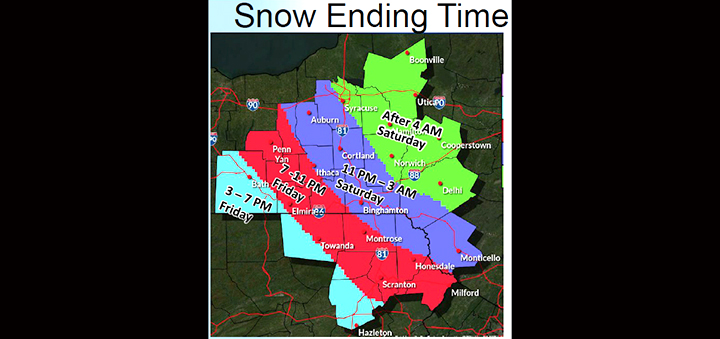 After initially indicating the area had avoided the worst of a predicated storm early Friday, the service has updated the prediction to include more severe weather for Friday afternoon. (Image from the National Weather Service.)
CHENANGO COUNTY – At about 11 a.m. on Friday the National Weather Service shared new information about Friday's winter storm.
After initially indicating the area had avoided the worst of a predicated storm early Friday, the service has updated the prediction to include more severe weather for Friday afternoon.
“Just received a phone call from the National Weather Service in Binghamton regarding a potential increase in snow fall for Chenango County,” said Chenango County Office of Emergency Services Director Matthew L. Beckwith at 10:55 a.m. Friday.
Officials had reported above average temperatures Friday morning and hoped the area would avoid major weather if those temperatures stabilized, but that doesn't seem to be the case.
“As you can tell, this is a very rapidly changing system as the temperatures hover around the freezing mark. We have seen forecasted rain turn to snow and forecasted snow turn back to rain as this system continues to impact our area. Currently, we are seeing precipitation in the form of snow and that will continue throughout the day today.”
According to the NWS in Binghamton, currently the radar is showing the heaviest snowfall is between Cortland and Otsego County, directly over Chenango County.
“This pattern will continue through this afternoon before snow begins to taper off around 5 p.m. today. We could see new increased snowfall rates from 1” to 2” per hour with snowfall accumulations over one foot of new snow. Some higher elevations could see higher amounts,” said Beckwith.
This increase in wet heavy snow will make travel very difficult today into this evening.
“Power outages are also a very large concern as the build up of the wet heavy snow could bring down trees and power lines causing some major outages. Fortunately, winds are expected to be around 16 mph. Currently, according to NYSEG’s outage reports, we only have six people without electricity, thus far,” he said.
“Snowfall rates are expected to diminish around 5 pm today. We will still see snow flurries and some minor additional accumulations until the front is completely out of our area, early Saturday morning,” he said.
Officials said early Friday morning the Chenango County area escaped the worst predictions of a Friday morning winter storm by a few degrees.
Weather officials, emergency crews, and NYSEG feared the conditions were creating a recipe for a repeat of a storm similar to the one that occurred in April, which left heavy snow and ice.
On April 19 the county declared an emergency over that storm and more than 15,000 residents were left without electricity in Chenango County.
Beckwith said the temperature was warmer than expected, just above freezing, and it had made a significant difference early Friday morning.
“We got an average of four to five inches. Temperatures are warming more than anticipated and a lot of the snowfall became rain this morning, reducing the total snowfall, obviously,” said Beckwith.
He said the area would not be totally out of the woods until later this afternoon, so long as the temperature doesn't drop.
However the storm's front falling over the area shifted and has proven unpredictable. Now officials see an increased chance of severe weather throughout the day.
In response, EMS, road crews, and NYSEG are prepared for the worst, he said.
Beckwith said road crews began major efforts to clear the roads this morning between 2 and 3 a.m.
A number of minor issues related to the storm were reported early Friday morning including a few outages and accidents, but “nothing major,” reported officials.
In anticipation of the storm all local schools and some offices closed Friday
Afton Central School District: Closed, Boys JV and Varsity basketball games moved to Monday, December 19 at 5:30 and 7 p.m. in Harpursville.
Bainbridge-Guilford Central School District: Closed.
Greene Central School District: Closed.
Norwich City School District: Closed.
Holy Family School: Closed.
DCMO BOCES: Harrold, Pole, and Support Services buildings are closed.
Otselic Valley Central School District: Closed.
Oxford Academy and Central School District: Closed, Primary School 3rd and 4th grade Winter Concert rescheduled to Monday, December 19 at 8:30 a.m.
Sherburne-Earlville Central School District: Closed.
Unadilla Valley Central School District: Closed.
Gilbertsville-Mount Upton Central School District: Closed.
(The Evening Sun is printed at about 10 a.m. every week day, after publishing the initial story this morning this article was updated with new information at about 11:30 a.m.)
Author: Tyler Murphy - More From This Author
Comments