Off The Map: Week Three, The Return To Dunraven
Published:
July 19th, 2010
By:
Bryan Snyder
If only I hadn’t misread the map the first time, back in 2007, then I wouldn’t need to violate the boundaries of the fire closure and sneak into an active forest fire zone. But three years earlier, the misinterpretation of contour lines had caused me to accidentally bypass Dunraven Peak, so my quest to climb the fifty highest peaks of Rocky Mountain National Park demanded a return to the isolated northeast corner… even though a thousand-acre fire was currently smoldering somewhere in the close vicinity. Some might say I was compounding my earlier stupidity with foolhardiness; I maintain that having learned about the ten day-old Cow Creek Fire only the night before, I was an innocent victim of Mother Nature’s bad timing.
The Cow Creek Trailhead had re-opened just that morning, but the Mount Dunraven region remained closed to the public. Stretching the concept of “freedom of the press” to its fullest, I slipped off-trail soon after beginning the hike, intending to do a complete loop around the burned area in order to reach several obscure peaks that were on my list. Sheep Mountain, the first to be reached after a bout of bushwhacking, was an unpretentious, forested peak whose summit log was just a notepad in a mason jar. I was the only person this year to bother to reach the summit, and the notepad dating back to 1992 held very few names. Once again, I was treading through territory that saw little attention, even from hiking stalwarts like myself, so I couldn’t count on an easy rescue should plans go awry.
At 11,000 feet above sea level I stumbled upon Potts Puddle, a hidden pond whose name derived from a practical joke played between two park rangers in the 1950s. Jack Moomaw stocked the pond with 2,000 rainbow trout fry, knowing his friend Merlin Potts was studying bighorn sheep in the area and would stumble upon the site sooner or later. When Potts “discovered” this fishing hole, he was ecstatic about the abundant catch and attempted to keep it hidden from other anglers, calling the pond a mere “puddle”. But word leaked out, and before the end of summer, Potts’ Puddle had been fished barren once more.
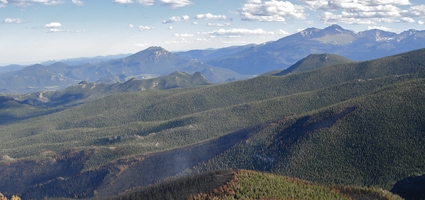
The hour was growing late as I closed in upon distant Mount Dunraven. Mica crystals in the granite were now glittering from the setting sunlight, and I gained the 12,571-foot summit feeling some trepidation about the remaining distance. On the slopes below, a herd of six female elk paused in their progression to stare up in my direction, necks turned in perfect unison, frozen in place like soldiers paying their respects to the current King-Of-The-Mountain.
One could say the old King-Of-The-Mountain was the infamous Earl of Dunraven. He was a wealthy Irish nobleman who manipulated the Homestead Act and tried to purchase the entire Estes Park valley as his own private hunting preserve. Eventually, he claimed 15,000 acres of present-day Rocky Mountain National Park, but constant litigation and hostility from settlers led the Earl to surrender his plans by the year 1907. The great hunter lost his quarry, but at least he managed to have this minor summit named after him.
Descending from Dunraven, I now drew close to the edge of the Cow Creek Fire. Local firefighters, confident that the side facing civilization had been suppressed, were content to let the rest of the fire creep towards treeline and burn itself out. From my vantage point, the burned area looked like a black stain that had splashed across the West Fork basin. Dropping further, I began to make footprints in the fresh ash, and the smell of charred needles was overwhelming. I was tempted to try and cross the devastated region, speculating that it might be easier to weave my way through a host of skeletal trees instead of bushwhacking through dense, green forest to reach my vehicle, but four or five plumes of smoke still erupted from scattered valleys in the basin, and I reconsidered.
The final leg of the journey became an endless bushwhack through tumultuous terrain as the sunlight continued to diminish. Disintegrating corpses of dead trees would burst open in a cloud of red powder when I tried to walk across them. Robins trilled plaintively, and the only other sounds in the forest were the hyperactive trilling of unseen hummingbirds and the murmuring of a creek as I followed it steadily downstream. It felt thrilling to roam through an area so obviously unaccustomed to man’s presence.
Then I came across part of an elk skeleton. A leg, a pelvis, a backbone. Bright red blood still stained some of the tendons, so perhaps the animal met its demise rather recently. I didn’t think much of the scene until I noticed…. a second backbone. Now the hairs suddenly stood up on the back of my neck. There was something inherently creepy about finding more than one set of vertebrae, for immediately my mind began to visualize the predator that had dragged elk here on two occasions and eaten them. I kept one eye on the surrounding cliffs after that.
Dusk had overtaken the forest by the time I stumbled upon the North Boundary Trail. From here, only four miles of straightforward hiking remained until my loop around the Cow Creek Fire would be complete. My paranoid side eased up, and I ceased to look for the flick of a mountain lion’s tail in the bushes. It had been an exhausting day… an enormous expenditure of effort, and all to rectify a trivial topographical mistake. Long live the Earl, and may I never have to visit his mountain again. At least not anytime soon.
Author: Bryan Snyder - More From This Author
Comments