Confirmed Tornado And Microburst Cause Widespread Damage In Area
Published:
July 24th, 2026
By:
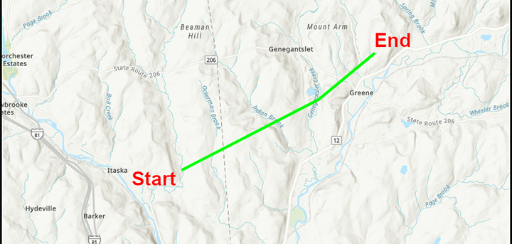 The tornado started in the Town of Barker before moving north and east to the Town of Greene. (Graphic from NWS)
NORWICH — The National Weather Service has confirmed that an EF1 tornado touched down in the Town of Greene on Tuesday. The tornado started in the Town of Barker as an EF0 with winds of about 80 mph and continued on a path northeast toward Greene, with winds increasing to 88 to 110 mph, causing tree and power line damage as it tracked over Ingraham Road, Indian Brook Road, County Route 2 and Laurel Road in the Town of Greene.
Several dozen hard and softwood trees had snapped trunks and blowdowns along this path. One eyewitness on County Route 2 experienced the tornado damage to several trees on his property, while another eyewitness on Laurel Road described the storm damage moving up the hill just north of his property.
The tornado maintained strength and dipped into portions of the Village of Greene, affecting wooded areas along Meadowbrook Lane, Grace Drive and Page Brook Extension. Damage became less obvious after passing over State Highway 41 to the west of Route 12. It is concluded that the tornado lifted and dissipated before reaching County Route 3A; however, sporadic downburst wind damage to trees and power lines occurred on the flanks of the tornado track along Route 12 to Brisben. Some tree limb damage from downburst winds away from the tornado track was also observed in the Village of Greene.
This damage was in addition to the issues caused by a strong microburst during Saturday’s storm in the Norwich area. That storm moved across the northern to eastern sides of the city and the core collapsed onto the area around 3:50 p.m.. There was significant tree damage and some resultant damage to residences and vehicles. The highest wind speeds were estimated to be between 80 to 90 mph along State Route 12 into Weiler Park. Besides this focused microburst, the line of storms caused pockets of wind damage in other parts of Chenango County as well.
A microburst is defined as a convective downdraft with an affected outflow area of less than two and a half miles wide and peak winds lasting less than five minutes. Microbursts may induce dangerous horizontal or vertical wind shears, which can adversely affect aircraft performance and cause property damage. A tornado shows rotation in addition to high velocity winds.
— Information from the National Weather Service
Comments