Off The Map: Week 13 - Pass Or Fail
Published:
September 26th, 2011
By:
Bryan Snyder
As a plan, it seemed reasonable on its surface. Over two days I would hike upstream along Convict Creek to its icy headwaters, find some way to cross over into the nearby McGee Creek watershed, and finish by following McGee Creek out of the mountains and back to the expansive Long Valley. These two beautiful Sierra Nevada trails had no officially sanctioned route linking one to the other, but who was I to keep them apart?
I spent many hours on the first day huddled in my tent, flipping through a Stephen King paperback and waiting out the persistent afternoon thunderstorms. The following morning, skies were cold and clear as I forged my way past a succession of lakes that became more rocky and barren as the altitude increased. The trail I was following faded into nonexistence, and there were no cairns to provide clues as to the paths taken by previous explorers. To breach the headwall of the valley and connect with an established route in the McGee Basin, I would have to discover my own mountain pass.
There were three low points along the mountain ridge separating me from the McGee watershed, and I labeled them left to right as easy, moderate and hard. The left route looked like a true mountain pass; hopping over would be relatively simple, though it would take a while to descend and reach the McGee Creek trail on the other side. The right route involved a slippery snow gully and a rough ascent of 13,163-foot Red Slate Mountain.
I chose the middle course – another snow-filled gully with a prominent rib of stone that protruded through the snowpack. The snow glistened whenever sunlight broke through the gathering clouds and struck its surface. I hoped this might be a sign of meltwater rather than ice, but such was not the case. The snow here had recrystalized and hardened, and only the tips of my hiking poles could penetrate the tough outer shell.
The snowfield also appeared to be scalloped and pitted from a summer of sporadic melting. The lower edges of each cavity provided footholds, but the sides and upper edges were barriers to upward passage. Still, I did my best to angle up and over towards the rock rib, guessing I could climb the rib and avoid the steepest part of the slope. But the gully became more vertical the more I traversed across it, until I was almost certain that I would slip before I could reach bare stone. The sharp points of my collapsed hiking poles were the only things keeping me affixed to the mountain, as my cheap sneakers with their remaining sixteenth-inch of tread provided zero traction. I was operating at my limits of skill and surefootedness here. And the last twenty feet of icy snow left to cross looked anything but forgiving.
I took another step forward, and then both feet lost purchase. My body dropped, and my hiking poles were not pushed deep enough into the snow to arrest my fall. In no time I was skidding down the gully and accelerating at an alarming rate. I grabbed the lower half of one of my poles, but I wasn’t heavy enough to force its tip through the icy crust. The point skidded uselessly across the surface while ice crystals tore at my forearm. I couldn’t even slow myself down. This is why smart people bring ice axes to the mountains.
I hadn’t thought I was in particular danger before I slipped, but at the speed I was traveling, I could very easily hit the lower edge of a deep scallop in the snow and dislocate something. Like half my spinal column.
Ultimately, after sliding two hundred feet, the slope tapered off and I was able to gracelessly claw my way to a complete stop. This was a serious setback, and afternoon thunderstorms were already coalescing in the skies above. Nothing to be done but slightly alter my strategy and give it another try.
First, I examined my wounds. The top layer of skin was gone from parts of one shin, and abrasions had left my forearm looking like a puppy’s plastic chew toy. A Hollywood makeup artist could have taken notes on the appearance, because my arm looked a bit like it belonged to a zombie… rotting away from the outside in. I wasn’t overly upset; for all the time I spend in the backcountry, I was due for some roughing up.
I resumed the ascent. This time, I approached the rock rib from below, but I found that the lower half was still too sheer to climb. I had to remain on the snowfield and skirt alongside the rib until I spied a place where my hands might gain purchase. But to reach it, I needed to cross one last treacherous five-foot stretch without sliding on the ice and repeating my previous mishap. I ended up spending ten minutes chiseling a pair of footholds in the snowbank rather than risk another uncontrolled slide.
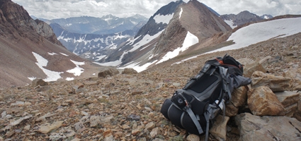
Climbing the rock rib was risky, but it served to take me to the top of the pass. From there, I could spy a genuine Forest Service trail not a quarter-mile away, one that would take me to the McGee trailhead, ten miles distant. However, since I was now only 1,200 feet below the summit of Red Slate Mountain, I gave into temptation and left my pack in order to take a detour to the top of the highest peak in the region.
Broken shards of slate tinkled beneath my feet like wind chimes as I climbed. And the views from the summit reminded me why I had sought out this part of the Sierras. The mountains here were composed of twisted bands of red and gray metamorphic material, and they exhibited a pattern similar to fudge swirled in cake batter. I suppose these peaks could have looked tortured, but the mountains seemed delighted to possess such unique colorations. I soaked up as much of the scenery as I could before the clouds dropped and ushered me back down the mountainside.
Ten miles later the sun was about to set, and I belatedly realized that hitchhiking from the McGee trailhead to Convict Lake at this time of day would be nearly impossible. There was not enough traffic. I had resort to Plan B, which was to leave the trail and climb another 2,000 feet, leapfrogging up and over McGee Mountain to reach my vehicle at Convict Lake. The route was definitely the shortest distance between two points, according to my map, and no cliffs appeared likely to bar my way despite the steep terrain.
The first flaw in my scheme was that the sagebrush slope was more densely packed with shrubs than I had initially thought. They scratched painfully at my wounded shin as I pushed past them. It seemed to take forever to fight my way to the top of the ridge, and by then dusk had settled on McGee Mountain. I started to rely on my night vision, and eventually the bushes and shadows lost their distinct edges and began to look like amorphous blobs of black and white. I maintained a steady pace on the downhill side, using my hiking poles as a blind man uses a cane, feeling for changes in topography.
Starlight provided the only illumination as the dark surface of Convict Lake came into view for the first time. Almost there. I had to put a lid on the machismo and pull out my solar flashlight when the slope suddenly became a bit more treacherous. A headlamp would have been more convenient; since I only had two hands, I had to give up one of my hiking poles, which felt almost as awkward and perilous as going blind. The probability of falling on my face during the descent went up tenfold.
After coming across a small, dry streambed, I followed it down the mountainside, although shrubs periodically congested the gully and blocked my way. A wider streambed would have been nice. Then again, if the streambed were any wider, it probably wouldn’t have been dry.
Time stretches when you’re dropping endlessly into darkness. “I should have reached sea level by now,” I thought to myself, “let alone the shoreline of Convict Lake.” At last, a parking lot appeared through an opening in the bushes… I had finally arrived at the end of the lakeshore road.
I stumbled out of the shrubbery and headed towards a map on a wooden signboard. Illuminated by my weak flashlight, a marker told me “ YOU ARE HERE.” I had enough geographic awareness to know that I wasn’t actually “HERE”… at least not where the map indicated I was supposed to be. But the distance between my true location and “HERE” was close enough, and more importantly, I knew how to get from this parking lot to the trailhead. I clicked off the flashlight and followed the road, completing the day’s journey in my preferred style… by starlight.
Bryan is a 1991 Norwich High School graduate and works as a naturalist at the Rancho Alegre Outdoor School in Santa Barbara, CA. You may reach him mid-journey at foolsby@hotmail.com.
Author: Bryan Snyder - More From This Author
Comments