Off The Map: Week Seven, Heavy Weather
Published:
August 16th, 2010
By:
Bryan Snyder
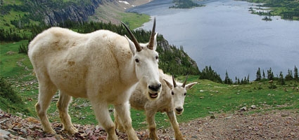
Right in the middle of the trail. Great place to put a mountain goat. If it wasn’t all cute and shaggy, like Santa Claus’ beard, I’d be a little more annoyed. I felt bad about disturbing the tourists next to me who were taking pictures, but I really had a long way to travel, and I wasn’t sure if the weather would hold long enough for me to reach Sperry Glacier.
I strode up to the long-snouted creature, which rose up on knobby knees and shook its sharp horns at me, but the gesture had too much of an edge of laziness to be convincingly threatening. He moved aside to join his cohorts down the mountain, allowing me to proceed deeper into Glacier National Park.
Nestled between Montana’s Flathead River and the Canadian border, Glacier National Park contains some of the finest examples of mountain-building that the Rockies have to offer. Around 170 million years ago, a block of material three miles thick broke free from the continental crust and was thrust fifty miles east, forcing it to clamber atop the backs of other layers of rock and giving it a much higher viewpoint across the western plains. Subsequent scouring by glaciers gave the uplifted land a tousled appearance, full of dips and waves, as if the scalp of the world had been attacked by hair gel and whipped by teenage hands into spikes and fantastical shapes.
Accelerated climate change has cut the number of active glaciers in the park from 150 in the mid-1800s to about 25 today, and I planned to cross the foot of one of them on this afternoon’s journey. Unfortunately, the weather didn’t hold nearly as long as I had hoped. I saw a few ground squirrels rushing to harvest dry grasses to stockpile in their holes, and then the rain started to come down. I wished I’d had a wooly white coat to protect me like those mountain goats, but I’d forgotten my rain pants, and my shoes quickly became soaked from the wet tundra grasses.
Still, I pushed on towards the lip of Avalanche Basin, the bitter wind driving raindrops faster and faster into my exposed face as I left the protective shelter of the mountain headwall and met the full force of the storm. The last twenty feet to the overlook was a grim, squint-eyed trudge, and my eyeballs hurt like they were freezing in their sockets.
When I reached the edge, I tried to gaze across the alpine plateau and make out the form of Sperry Glacier, my next destination. But clouds had touched down upon the tundra, and even with narrowed eyes I could tell that visual navigation would be impossible. Traveling off-trail without landmarks in the vicinity of cliffs and glaciers was a suicidal endeavor, so I reluctantly turned around and began the five-mile hike back to the trailhead.
There was only supposed to be a 20% chance of isolated thunderstorms that day. It was hardly fair. Instead, spectral clouds were hungrily tearing at the mountains in all directions, and I was finding it impossible to bring warmth back into my benumbed fingers. Even the goats were taking shelter from the wind and rain, chewing whatever grasses they could find beneath overhangs in the cliffs above my route.
I returned to civilization and groused about the fickle weather all evening, but by the next morning the skies had mostly cleared, despite a forecast predicting that conditions should be less favorable. I guess there’s no reasoning with Mother Nature. Rather than retrace my steps towards Sperry Glacier, I chose to pursue Mt. Siyeh, one of the six peaks above 10,000 feet within the park.
A few years ago, a park ranger handed me a ten-page manual on how to scale the mountain. Part of me scoffed at the level of detail and wondered if it would needlessly take all the adventure out of the climb, but knowing the brittleness of the local rock material, it was more likely that the route left little margin for error.
The guide helped to position me beneath the easiest passage through the cliffs on the south face, but from there, the ascent was mostly a straightforward slog through slippery, multicolored scree until I reached the crux of the climb: a 30-foot cliff band through which the author had mapped out five possible routes. Also, embedded within the cliff was a small cave with an overhanging rock slab for a roof. Since I’d seen three bears in the last two days, my imagination immediately thought, “grizzly den,” though my logical side ruled out the possibility due to the elevation.
A small ray of sunlight glimmered in the back of the cave, so I scrambled inside to investigate. A triangular hole penetrated a corner of the ceiling, and it looked accessible to a skinny hiker, as long as he didn’t accidentally pull the cave down on top of himself. I pushed my hiking poles and backpack through, then wriggled up the hole, popping out right at the top of the cliff. Ha! Ten pages … practically a doctorate thesis on the mountain, and the easiest route through the cliff band wasn’t even in there!
The storms that had been forecasted never made an appearance, and so I was given plenty of time atop 10,014-foot Mt. Siyeh to enjoy the majestic, sunlit views of which I’d been robbed the day before. Below me, on the north side of Mt. Siyeh, was another dizzying spectacle: a 4,000-foot plunge straight down to the shores of turquoise-colored Cracker Lake. Get a running jump, and your plummeting body wouldn’t graze against the cliff for at least 3,000 feet. I found I could only look out over the precipitous edge while lying on my belly, as the capricious wind at my back was not to be trusted.
To the northeast, the Mt. Siyeh ridgeline extended five miles to the summit of Wynn Mountain, named after a renowned advocate for environmental conservation at the turn of the century. Dr. Wynn took frequent breaks from his Indiana medical practice to vacation in Glacier National Park, leading parties on first ascents of several major peaks. In 1922, however, 58-year old Wynn had a sudden stroke while climbing Mt. Siyeh and pitched forward off a narrow ledge, falling to his death. Obviously, it didn’t happen near the top of Mt. Siyeh, because the reports say he only fell 300 feet. Still, considering the lingering deaths one might potentially suffer at the end of one’s life – Alzheimer’s Disease, diabetes, cancer – I’d say that slipping half-conscious off the side of a cliff while doing something you love seems like a pretty nice way to go.
Bryan is a 1991 Norwich High School graduate and works as a naturalist at the Rancho Alegre Outdoor School in Santa Barbara, CA. You may reach him mid-journey at foolsby@hotmail.com. Look for Bryan’s columns on our Facebook page – www.facebook.com/theeveningsun.
Author: Bryan Snyder - More From This Author
Comments