Changes To Flood Plain Maps Will Affect Homeowners' Insurance
Published:
September 15th, 2009
By:
Michael McGuire
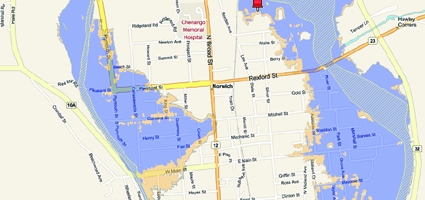
NORWICH – Federal and state officials have announced changes to the county’s designated flood plain that will require a new group of homeowners to purchase disaster insurance for the first time.
The re-drawn county maps, which haven’t been updated since 1985, will give others the option to cancel their flood coverage.
Several streets in the City of Norwich have been removed, while “significant” parts of Oxford and Sherburne have been added, according to the preliminary boundaries released earlier this month.
The Federal Emergency Management Administration (FEMA) and the state Department of Environmental Conservation (DEC) are holding an open house for the public from 5 to 8 p.m. Wednesday in the Summit Room of the Eaton Center in Norwich to discuss the changes.
The new maps, undertaken after the county was declared a disaster area in 2006, are not yet official and still considered draft proposals. Over half the other counties have been redrawn as part of broader effort started in 2004.
“From what I saw, there are quite a few homes in the villages of Oxford and Sherburne that have now been included that weren’t before,” said A. Wesley Jones, the City of Norwich’s Emergency Management Officer, who said he’s been examining the changes with other area emergency officials.
No specifics figures were available on the number of homes added or removed from the flood plain. The maps will be subject to a 90-day appeals process to start within the next few weeks or months.
Author: Michael McGuire - More From This Author
Comments