Off The Map: Versus The Volcano
Published:
August 26th, 2013
By:
Bryan Snyder
Editor’s Note: After a year's hiatus, the chronicle of Bryan Snyder's misadventures in the Western high country, "Off The Map", returns to the pages of The Evening Sun. Besides the usual tales of Rocky Mountain mischief, Bryan will report from the drought-afflicted backcountry of Southern California and the snow-capped, slumbering volcanoes of the Pacific Northwest.
Bryan Snyder
Correspondent
Two volcanoes in two days. Not an ideal schedule, but the predicted weather for southern Washington was strongly pushing me in this direction. As far as mountains go, these volcanoes were monstrosities – giant composite cones of ash and lava that dwarfed all other peaks in the state. Having a day to recover in between climbs would have been hugely appreciated; unfortunately, thunderstorms in the extended forecast would not allow it.
First on the list was Mount St. Helens. The infamous 1980 explosion had hollowed out the volcano and taken several feet off the top, so I had 1,300 feet less to climb than I would have had in 1979. Still, the elevation gain of 4,600 feet was substantial.
As the forested trail began, I was made to feel welcome by patches of soft, blue lupines, which complimented the rich greens of the fir trees and huckleberry bushes. A gap in the branches looked out upon a billowing, white sea of fog that broke upon the shores of isolated mountaintops. To my eyes, these lesser ridgelines resembled hunchbacked beasts that moved silent and herd-like through the smoky waters. And beyond these creatures to the south was volcanic Mt. Hood, proud as a lion, rising above them all.
Once free of the forest, it was hard to turn away from the panorama of clouds and hilltops, for the alternative activity was to trudge up a mountainside while staring at drab, grey cinders. Only the occasional burst of magenta fireweed helped relieve the dreary color palette. Cinders eventually gave way to large, volcanic boulders, which felt porous and insubstantial as I walked across them. I almost suspected I could pick one up and hurl it down the mountain, like a stage prop.
Many other pilgrims were scaling the volcano, but I set an ambitious pace and slipped past dozens of them, gaining altitude even as the fog receded from Mt. St. Helen’s slopes. After one final push through a level of ashes and cinders, I reached the rim and was immediately stunned. I literally had to choke off a swear word because the view was threatening to short-circuit my receptors for astonishment and wonder.
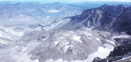
Before me stretched a blasted landscape, beginning with a vast crater that had only partially filled in with a steaming lava dome over the last thirty years. The north side of the volcano was completely obliterated, revealing the mudslides that had dammed and raised the level of Spirit Lake. I was mystified by a flat, grey mass that coated part of the surface of Spirit Lake until someone explained it was a mat of logs deposited by a megatsunami after the 1980 explosion. These trees had been ripped from the hillsides, and decades later they were still in the process of sinking to the lake bottom.
Out past Spirit Lake, Mt. Rainier, with its complex topography of ridges and glaciers, dominated the northern horizon. Eastward rose the massive bulk of Mt. Adams, which I would attempt to climb on the morrow. Maybe in another thousand years, Mt. St. Helens will have built itself back to the point where it could rival its brother and sister volcanoes again. For now it was still crumbling, and frequent plumes of dust from falling boulders reminded me not to stand too close to the edge of the summit crater.
The descent began with a joyous glissade down a lengthy snowfield. Sliding on one’s boots and waving one’s arms to keep upright can quickly stress out the shinbones, but it’s much easier on the knees and is a great way to drop a lot of elevation in a short amount of time. However, if you’re not observant, you can slide too far… just like a bus rider who misses their stop and has to disembark, get their bearings and try to reconnect with their original destination. I made this exact mistake, of course, and luckily managed to find my way through the lava fields back to the trail before I wandered too far down the mountain.
At the end of the trail, my legs were fairly tired. My middle toenails had turned a nice shade of lavender, and I had reopened wounds on my feet that were still healing from last week’s adventure in the Trinity Alps. But there was no time to rest! The next day I was staring at 12,281-foot Mt. Adams, the second-highest mountain in Washington State, and even after driving high-elevation roads to the trailhead, there was still 6,700 feet of altitude to ascend before I could reach the summit.
Needless to say, I wasn’t the fastest climber this time around. The upper slopes were grueling, and because a thin haze had settled on the region, the scenery wasn’t nearly as enjoyable. From the top of the stratovolcano, other peaks such as Mt. Rainier, Mt. St. Helens and Mt. Hood seemed dim and distant. I didn’t stay long on the windy and frigid summit before hoisting my pack and heading back down.
But here’s where the fun began. Enough hikers had slid down the snowfields of Mt. Adams that their backsides had worn a deep furrow into the snowpack. Instead of glissading down the mountain, this time I’d be sledding. Hours earlier, I had noticed a discarded length of bubble wrap, and I decided to pluck it from the snow and carry it with me. Now this piece of litter was going to fulfill its true purpose: to become a sled. I sat carefully on the padded sheet, pulled up my legs, teetered for a moment at the lip of the precipitous slope, and then plunged down the gully.
Soon I was rocketing downward with intense velocity, hooting with excitement as my body banked on the curves like a bobsled. Two thousand feet of elevation disappeared in two minutes, and there were enough unexpected bumps that I felt fortunate to have bubble wrap protecting my posterior. The chute also had icy ridges embedded in its sides, and at the speeds I was traveling, I had to be careful when banking so I wouldn’t tear up my padding or slice open my hands.
Sadly, the snowfield came to an end. I have never had so much fun descending a mountain. I rolled up the bubble wrap and squeezed the meltwater out of my gloves. At least my pants had remained dry.
The next snowfield lay on the opposite side of a ridgeline of lava rocks, but upon reaching it, I discovered that the wind had ripped the bubble wrap loose from the side pouch of my backpack! I retraced my steps but could not relocate my padded sled. Ah, well. Hopefully some other hiker will make good use of it, as I did.
I tried to slide without the bubble wrap, but it wasn’t long before my hip collided with a rock protruding through the thin snowpack, and I limped painfully the rest of the way off the snowfield. Soggy pants and bruises… not the best way to end an epic hike. But the predicted batch of thunderstorms were quickly closing in, and I was glad to get off the volcano in any condition, triumphant or otherwise.
Bryan is a 1991 Norwich High School graduate and author of "Off The Map: Fifty-five Adventures in the Great American Wilderness and Beyond", now available at Amazon.com. For additional photos, visit www.facebook.com/offthemaponline.
Author: Bryan Snyder - More From This Author
Comments