NORWICH – The Susquehanna River Basin Commission (SRBC) recently listed recommendations for improving flood monitoring and forecasting that may lead to Norwich getting a new and much more technologically-advanced river gauge.
“Based on the discussion I’ve had with the SRBC, I’m confident that we will be getting a river gauge,” said City of Norwich Emergency Management Officer A. Wesley Jones.
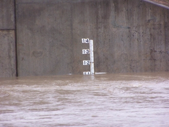
The SRBC’s recommendations, based on the June 2006 flooding, call for developing “crest-crest relationships for forecasts in New York at Norwich (Chenango River).” According to SRBC’s Director of Communications Susan Obleski, “the new gauge in Norwich would provide real-time data on the level of the streams, and the National Weather Service can make forecasts on that gauge.”
Norwich’s current staff gauge consists of a series of numbers painted on the side of the Rexford Street bridge. The numbers indicate the height of the river at that point. In the past, the flood stage was officially reached when the water hit the 11 foot mark. However, after the June flooding, the flood level was lowered to 9 feet. “By 11 feet, we’re already closing streets. Low-lying areas are flooded at 9 feet, and by 10 and a half feet, East Main Street starts to flood,” Jones said. During the recent flooding events, the water reached a height of over 12 feet.
Although there are electronic forecasting gauges in place in Sherburne and Greene, they did little to predict when the river would crest, or reach its highest point, in the Norwich area. According to Jones, the water had crested in Sherburne and Greene, but was still rising in Norwich. “We believe there is additional water coming into the watershed area through Tompkins Creek, Canasawacta Creek and Ransford Creek,” Jones said. That is why a river gauge in Norwich is so desperately needed, he said.

There's more to this story! You're only seeing 53% of the story.
powered by

